
The world is at increasing risk of global food shortage, natural disasters, global warming, ocean floor spreading, water scarcity, and increased greenhouse gas emissions. The key reasons for this are geopolitical conflict, supply chain disruption, and climate change. The figures are telling:
.png)
Sustainable development maintains a refined balance between the human need for well-being, while preserving natural resources and the ecosystems on which we and future generations depend. Locational information that represents the physical world in which there is human, economic, and environmental activity, provides a digital earth platformfrom where citizens, communities, industry, government, and other stakeholders benefit from location-based services, often unknowingly. The UN’s Sustainable Development Goals (SDGs) are highly dependent on geospatial information primarily from earth observation (EO) data that connects people to their location, and helps monitor progress at a specific region, district, state, or local level.
GIS along with location and sensory information has evolved into a comprehensive global platform, and supported by data science, has proved a key tool in assessment, prioritization, mitigation, planning, change management, and capacity building helping resolve challenges in economic inequality, social instability, and environmental degradation. This paper explores how the use of geospatial data helps achieve the SDGs, and reviews the UN’s work on various SDG indicators, particularly those that can be monitored using geospatial data.
Geospatial data is the key enabler for informed decision-making across industries—utilities, engineering, procurement, construction, transportation, telecommunications, energy, mining, and governments. As an end-to-end provider of geospatial solutions, Cyient has been leveraging the full potential of geospatial technologies combined with our global delivery model and agile processes along with building environmentally sustainable solutions. Our focus on designing and building sustainable solutions with effective business processes that integrate environmental sustainability into value propositions and customer experiences, enabled by digital- and data-driven efficiencies for end users, has established us as a trusted geospatial partner.
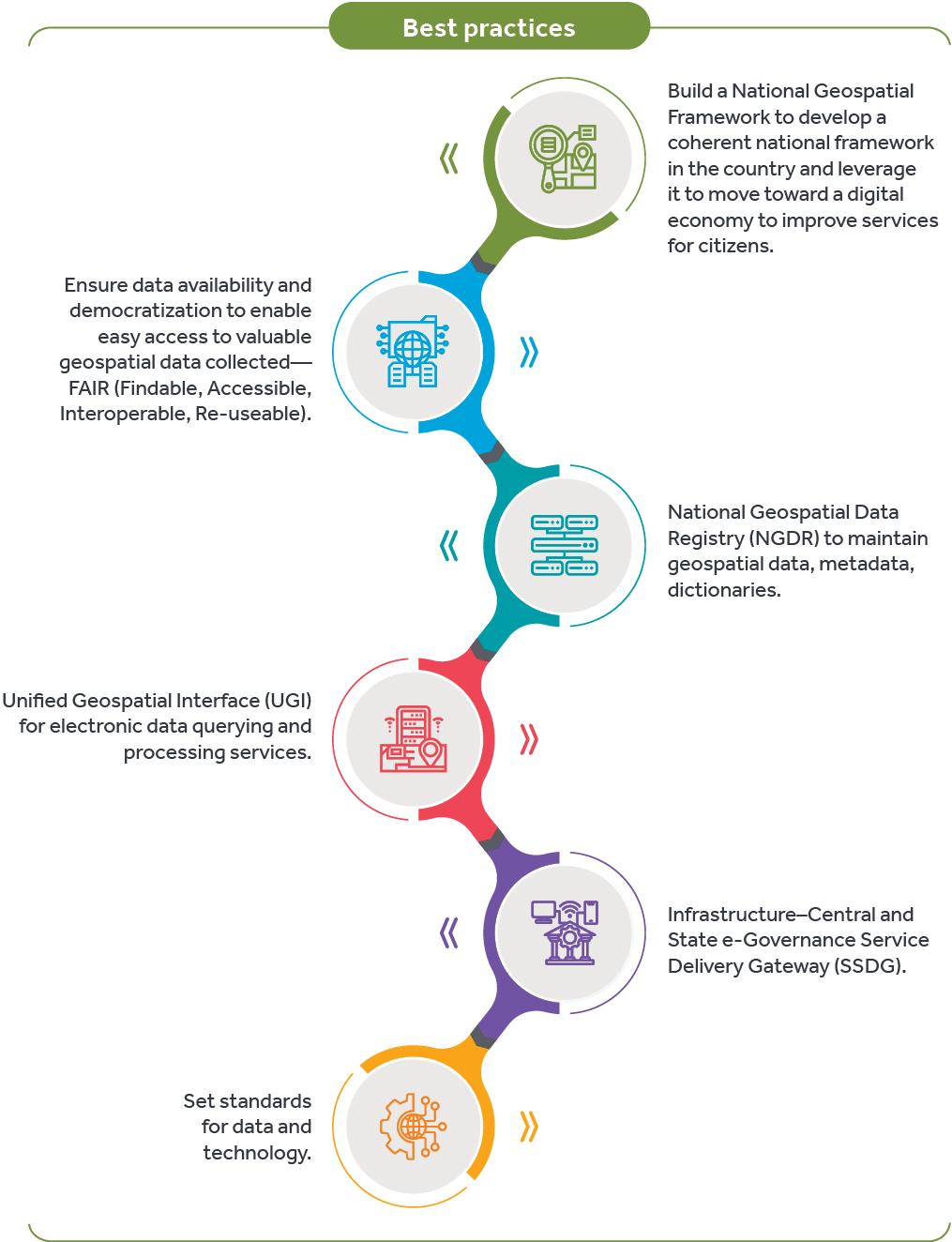
Despite an abundance of data and associated technologies globally, and access to reliable and consistent mapping data and analytics, there are gaps in geospatial policy, ecosystem, data standardization, and adoption and access to data and solutions. Geospatial digital transformation calls for bridging these gaps and the UN has outlined a National Geospatial Policy for country-level implementations to bring in seamless integration of geospatial data across countries for a unified view.
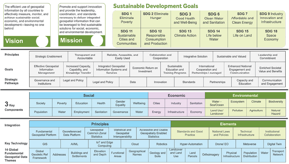
This work provides a comprehensive overview of three guiding frameworks: Integrated Geospatial Information Framework (IGIF), Global Statistical Geospatial Framework (GSGF), and Generic Statistical Business Process Model (GSBPM). Together, these enable the use of geospatial information for SDGs and outline an implementation framework.
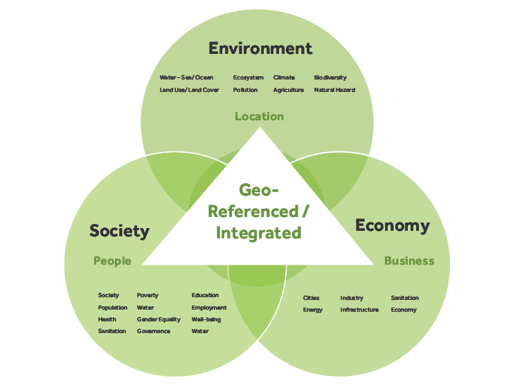
The 2030 Agenda for Sustainable Development, with its 18 Sustainable Development Goals outlines the process to understand, sustain, and develop the three pillars for development—economy, society, and environment—at a country level. It advocates maximizing positive outcomes in these three areas by enabling data-driven, evidence-based decision-making, Earth observation data gathers information about the physical, chemical, and biological systems of the planet detected via remote-sensing technologies, when integrating information from both statistical (wide-ranging socioeconomic and enterprise data) and geospatial data (environmental and earth observation data) for understanding relationships among and within these three pillars. The integration of this information is vital to improve the quality of the evidence we use to make present and future decisions.
Earth observation data gathers information about the physical, chemical, and biological systems of the planet detected via remote-sensing technologies, which is useful in achieving the SDGs. There are numerous satellite sensors with specific features, which are essential in monitoring and visualizing local and global changes. Earth observation provides key data for monitoring land use, soil, snow cover, drought and crop development, as well as water cycles, air quality, forests and other aspects of the natural environment, and the epidemiology of infectious diseases, directly addressing most of the UN’s 18 SDGs .
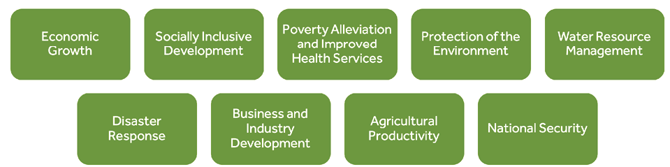
Governments and urban local bodies understand applications that are more traditionally geospatially-enabled, many of which are expressed in the SDGs—land administration and management, environmental protection, planning and land use, agriculture, water management, defense and national security, forest management, disaster management, infrastructure development, statistics and demographics, marine information, address management, telecommunications, urban planning, and more. They well understand issues around solving key problems of poverty and hunger alleviation, disaster response and mitigation, effective water resource utilization, recharging, national security and so on. What is needed is a national strategy for sustainable development—a strategic and participatory process of analysis, debate, capacity strengthening, planning, and action.
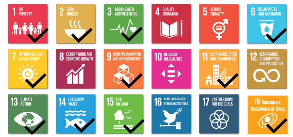
Below is a schematic representation of the 18 SDGs including those connected with spatial data (ticked). Some of the key use cases in each SDG are indicated below.
Understanding the product and identifying applicable standards as per the intended purpose of the product.
Identifying applicable regulatory requirements and preparation of regulatory assessment report.
Compiling the technical documentation, product registration, and launch.
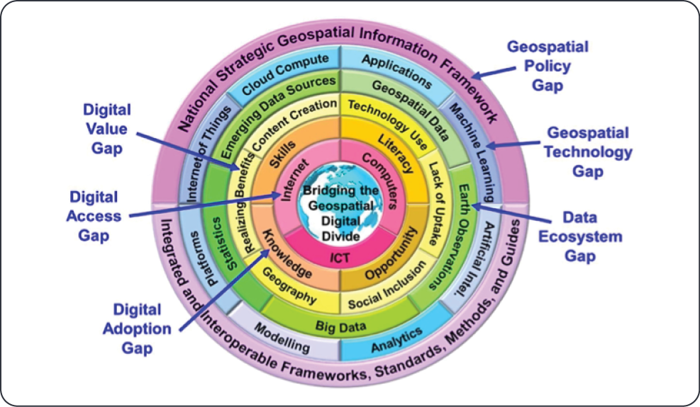
The Integrated Geospatial Information Framework endorsed by the UN, developed in collaboration with World Bank, aims at assisting countries to move toward e-economies, e-services, and e-commerce to improve services to citizens, to build capacity for using geospatial technology, enhance informed government decision-making processes, facilitate private sector development, take practical actions to achieve digital transformation, and to bridge the geospatial digital divide in the implementation of national strategic priorities and the 2030 Agenda for Sustainable Development.
The framework outlines nine strategic pathways—a matrix of Society, Economy and Environment with Governance, Technology, and People for Knowledge, Decision-Making, and Development.
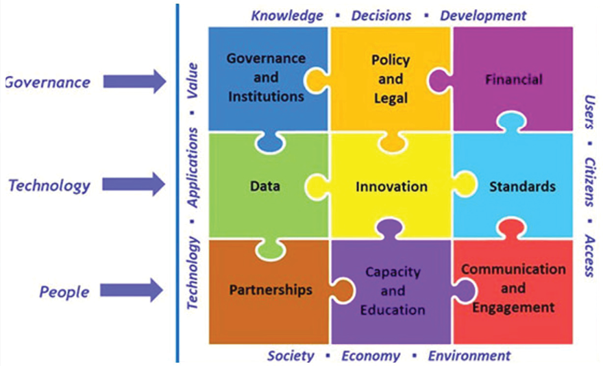
The United Nations Committee of Experts on Global Geospatial Information Management (UN-GGIM) outlines the underlying mechanism to achieve this integration, with the resulting output being geospatially enabled statistics that reflect a complete picture of our world. The framework identifies the following five Principles and four key Elements (that cut across the principles). The Principles guide implementing countries in establishing and strengthening their processes for geospatially enabling statistical and administrative data and allow for the identification of capacity gaps within their respective national statistical and geospatial infrastructure.
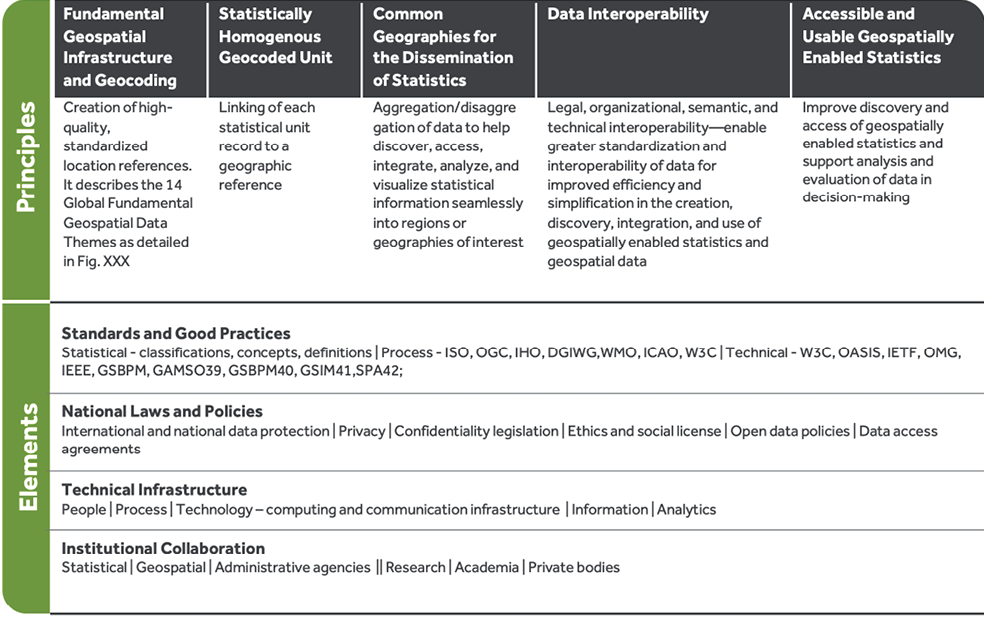
The three guiding frameworks—Integrated Geospatial Information Framework (IGIF), Global Statistical Geospatial Framework (GSGF), and Generic Statistical Business Process Model (GSBPM)—combine to enable the use of geospatial information for achieving the SDGs. These frameworks individually and collectively support the National Statistics Office (NSO), the National Geospatial Information Agency (NGIA) and provide a bridge between them. The inputs and outputs for these frameworks are the 14 Global Fundamental Geospatial Data Themes and their derived datasets.
The Statistical Commission and the Committee of Experts on Global Geospatial Information Management (UN-GGIM) has advocated the Federated System for SDGs (FIS4SDGs) to provide a complete enabling environment for national and international reporting for SDG integration by having interoperability within the national and global SDG ecosystem. Several countries of varying capacities have implemented the FIS4SDGs, demonstrating its applicability to guarantee the standardized management of SDG indicators, regardless of the data or methodology used in their production. The FIS4SDGs will assist countries with technology components of all phases of this implementation roadmap. The figure above depicts a comprehensive framework of implementation for achieving the SDGs.
A cloud-based solution to accelerate the regulatory compliance process. It helps to search worldwide regulations, and offers a digitized form regulation database for easy search and analysis. The standard module consists of a library of 1500+ international standards such as ISO/IEC/AAMI.
The solution offers a device classification tool, device-specific compliance, and regulatory intelligence services such as regulation assessment, gap assessment, and impact analysis.
Its regulatory watch feature monitors changes in regulations and provides a personalized news feed to users consisting of regulations news, safety communication, and warning letters.

Digital Skills—Foundational for SDGs Digital skills and geospatial technology are critical for a sustainable world. Technology-enabled measurements, data (via remote sensors and IoT devices, satellites), and connectivity, combined with AI/ML-based analytics play acritical role in monitoring and optimizing resource use. Core tasks of recording and reporting environmental impact rely on evolving digital tools. These tools help organizations understand and manage the risks that climate change poses to their business, track their carbon footprint and offsets, as well as develop strategies to set and meet sustainability targets.
Achieving the SDGs undoubtedly needs massive and concerted global efforts across industries, academia, governments, and research organizations to efficiently utilize data sharing, processing, and aggregation in a highly multidisciplinary framework. National geospatial information agencies will need to collaborate closely with national statistical and earth observation professional communities to deliver consistent and reliable data that helps formulate wide-ranging sustainable development policies. And finally, digital skills will be foundational to organizational sustainability roles.


Nihar R Sahoo is a PhD in Earth Sciences and Mineral Exploration with specializations in GIS, Remote Sensing and Applied Statistics, and has over 23 years of industry experience. His interest lies in building end-to-end development, deployment, and operationalization of geospatial solutions with earth observation and allied data.