Utility companies use several enterprise back office management solutions such as Innovaptive, SAP, and Salesforce, and connect to their frontline workers through their respective mobile workforce management applications for real-time data capture, immediate assignment of new work, and improved data accuracy.
In most mobile workforce management applications, enhanced map control with offline capabilities that allow workers to visualize and manage assets and work locations is missing. Hence the field crew has to spend more time updating data, which is mostly redundant, in multiple applications.
Cyient’s GIS adaptor can provide seamless integration of the map with the mobile workflow that streamlines work activities to better manage assets.
Mobile workforce management applications in most enterprise solutions need enhanced map control with offline capabilities that allow workers to visualize and manage assets and work locations.
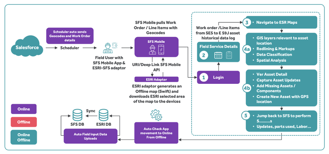
Cyient’s GIS Adaptor facilitates frontline users with all Esri GIS capabilities from work orders, operations, and notifications to equipment and functional locations. Field workers open the GIS adaptor to access the work location and initiate actions directly from the assets shown on the map.
The proposed solution, Cyient’s GIS Adaptor, offers the following features:
Viewing assets on the map enables field workers to see them in their true location relative to connected assets and customer locations. Crews can avoid unnecessary trips to assets that don’t require maintenance and see other crew locations on the map for better coordination and mutual aid.
GIS and enterprise asset data is synchronized and delivered online and offline. Workers can update asset information during installation or maintenance.
With a single application for mapping and work, crews spend less time on the screen and more time installing and maintaining assets. Office workers can spend less time re-keying information from paper forms, reducing processing time.
Critigen delivered GIS integration and map control for an asset management mobile application for a US-based combined natural gas and electric utility major.
As a result, 300 end users had a fully integrated, easy-to-use application that sped up their preventative and corrective maintenance programs for gas transmission compressors. The application also enhanced data quality, making regulatory compliance simpler for the utility. Using Critigen’s Geocache technology, end users were able to work effortlessly in remote areas in offline mode without any intervention on their part.
A field crew member commented, “Being able to see my work on an interactive map on my iPad as well as being able to start, work on, and complete my work orders made a huge difference to my workday.”

| S.No | Actor | Use Case |
|---|---|---|
| 1 | Work order creation | Created by the dispatcher based on case details and work type |
| 2 | Work order scheduling and dispatch | a. Dispatcher reviews the work order and updates the service. b. Work order is assigned and scheduled to an appropriate service resource automatically by the SFS scheduling function. |
| 3 | Scheduler | a. Scheduler auto-sends geocodes and work order details. b. Scheduler pushes work order/line items with geocodes to SFS mobile app. |
| 4 | SFS-Esri adaptor | SFS-Esri adaptor generates an offline map (Swift) and downloads selected area of the map to the device. |
| 5 | Deep link | Deep linking URI scheme for field service mobile app |
| 6 | Work order execution (crew) | a. Field user installs the SFS-Esri mobile adaptor (pre-requisite for the proposed). b. Field user logs into SFS mobile app and views the work order details c. Crew service resource receives work order from SFS and travels to site, makes an assessment, executes the work, and captures work completion details. d. Can navigate from SFS to Esri app (deep link between both the apps) e. The online/offline Esri app enables the crew to:
|
| 7 | Online auto check | SFS-Esri adaptor auto checks app movement from offline to online and uploads respective field input data to Esri and SFS DB. |
| 8 | Integration with Esri and SFS | Sync from Esri to SFS with geocodes and asset details. |
With Cyient’s GIS Adaptor, mobile workforce management applications in most enterprise solutions can work with enhanced map control online and offline to visualize and manage assets and work locations. The GIS Adaptor facilitates seamless integration of the map with the mobile workflow, streamlining work activities to better manage assets.
Cyient works closely with the industry experts, equipment manufacturers, and aftermarket customers and has come up with an industry leading report that showcases decade defining Megatrends that will shape the Utilities industry. Focus areas ranges from "Sustainable Business", "Intelligent Products", and "Augmentation and Smart Connected Solutions" to name a few.

Megatrends: Cyient works closely with the industry experts, equipment manufacturers, and aftermarket customers and has come up with an industry leading report that showcases decade defining Megatrends that will shape the Utilities industry. Focus areas ranges from "Sustainable Business", Intelligent Products", and "Augmentation and Smart Connected Solutions" to name a few.

Sai Ramesh is an engineering graduate, he has over 24 years of experience in the field of IT, and extensive knowledge in the areas of GIS, automation, and utilities. He has executed long-term projects independently in the US, Middle East, and India, and completed major projects in GIS.
Sai Ramesh
Delivery Director,
Industry Offerings – Utilities, Cyient
Cyient (Estd: 1991, NSE: CYIENT)delivers Intelligent Engineering solutions for Digital, Autonomous and Sustainable Future
© Cyient 2024. All Rights Reserved.