Abstract

Agriculture, a vital sector in the global economy, needs an in-depth analysis of the end-to-end agricultural supply chain for its sustenance. Some of the key challenges include poor forecasting of market demand, production volume, poor traceability, inefficiencies in logistics, and limited transparency, all of which are exacerbated with climate change, population growth, and dwindling natural resources. In addition, the farmer-producer-distributor-broker-consumer location and network need detailed analysis. To achieve sustainable practices, it is essential to optimize agricultural supply chains, minimizing waste and reducing environmental impact while ensuring fair and transparent transactions.

The convergence of blockchain technology and geospatial artificial intelligence (GeoAI) holds incredible potential to transform the agricultural sector, provide an opportunity to address existing challenges, and create a more sustainable agricultural supply chain. It can bring a more efficient, transparent, and secure system to ensure quality and safety of agricultural products while reducing waste and improving sustainability. These technologies help address today’s pressing challenges by leveraging the vast amount of data available almost daily, and applying advanced AI/ML techniques to effectively and efficiently manage the supply chain, and strategize for sustainable agriculture.

Introduction

Geospatial artificial intelligence (GeoAI) plays a fundamental role in exploiting earth observation (EO) data about the earth’s surface, atmosphere, and weather to help monitor and analyze various elements of the agricultural supply chain—land cover, crop area, crop type, crop health and phenology, crop yield, production volume, biomass estimation, weather patterns, and logistics network—using machine learning algorithms. It also enables farmers to improve crop yields and reduce water usage while lowering the environmental impact of agriculture. 

Real-time monitoring of crop health, soil moisture levels, and pest infestations helps precisely target irrigation, fertilization, and pest control, reducing the excessive use of water, chemicals, fertilizers, and pesticides. Similarly, by analyzing data from the supply chain—crop yields, distribution network, transportation schedules, and weather conditions—GeoAI makes more accurate predictions and helps optimize the distribution of agricultural products, minimize energy consumption, and reduce food loss during transportation and storage. Blockchain ensures transparency and accountability, enabling stakeholders to identify and rectify inefficiencies in the supply chain.

Making Agriculture Resilient

GeoAI and blockchain empower supply chain stakeholders in the ecosystem to work collaboratively, making agriculture more sustainable and resilient. The following tasks, enabled by these technologies, help provide an efficient and effective sustainable agriculture supply chain management:

1. Planning

  • Site selection for farming: GeoAI uses multi-criteria, multi-objective analysis with parameters such as soil quality, topography, drainage parameters, rock type, soil type, topography, slope, aspect, relief, irrigation water supply, rainfall, temperature, evaporation, evapotranspiration, and other weather parameters to help farmers identify the right crops to plant in the right areas while optimizing land use for maximum yield with minimal environmental impact.
  • Environmental impact mitigation: Identify areas prone to erosion, salinization, or waterlogging basis topographic parameters, soil chemistry, and weather data, and using machine learning models recommend appropriate measures to mitigate these environmental challenges and reduce the impact on soil health ensuring sustainable agricultural practices.
  • Weather forecasting: Earth observation can provide accurate weather forecasts, which can help farmers and suppliers plan their operations accordingly.

2. Crop Monitoring

  • Harvest prediction: GeoAI can predict harvest yields based on a variety of factors—weather patterns, crop phenology, historical crop yield data, and other secondary information including geogenic parameters and crop growth rates. By predicting yields in advance, farmers can plan for transportation, storage, and processing needs, and make informed decisions about pricing and sales strategies.
  • Crop health monitoring: Using crop phenology, weather conditions, and historical data, predictive models help  farmers and suppliers make informed decisions about planting, harvesting, and logistics.
  • Precision farming: Farmers can precisely target areas that require intervention, such as fertilizer application or 
    pest control. ML models trained on geospatial data can identify variations in crop health and growth, helping farmers 
    optimize resource allocation and maximize yields.

3. Logistics Optimization

  • Earth observation along with routing algorithms on GIS can provide data on distribution networks, transportation 
    routes, traffic patterns, road conditions, and more. This information can help suppliers optimize their logistics 
    operations, reduce transportation costs, improve delivery times, and deliver sustainably.

Challenges of GeoAI in agriculture

  • The quality and availability of geospatial data including satellite imagery, and weather data besides secondary and ground truth data, can often be a challenge. It is critical to ensure that data is accurate and reliable to develop 
    accurate predictive models.
  • Integrating the geospatial platform with existing farming systems can be a challenge, particularly in smaller farms with limited resources.
  • Model accuracy in prediction often goes erratic due to large change in weather pattern compared to previous years, change in soil chemistry, terrain conditions due to minor irrigations, and other factors. Hence, it requires close collaborative efforts between agricultural experts, data scientists, and technology providers in training models with feedback looping.

Images 3-1

Crop Supply Chain Management as Solution

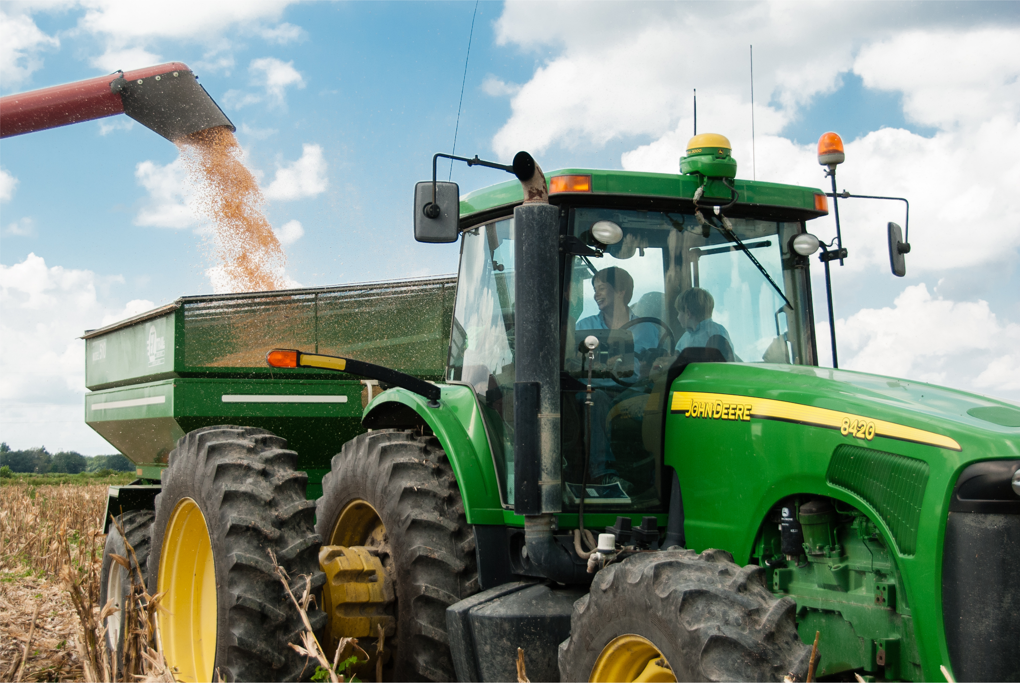
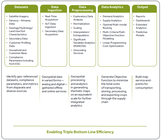
Crop supply chain analytics help farmers, traders, and investors make informed decisions about buying and selling crops. By analyzing data on crop yields, weather patterns, and market trends, crop market analytics can provide valuable insights into the supply and demand of various crops. This helps farmers optimize their crop production basis integrated analysis of various parameters such as selection of land including soil, hydrology, and other parameters, irrigation supply, and weather patterns. It also helps them make informed decisions about planning the cropping life cycle—when to plant, irrigate, and harvest crops. This enables maximizing yields and minimizing losses due to weather-related events such as droughts or floods.

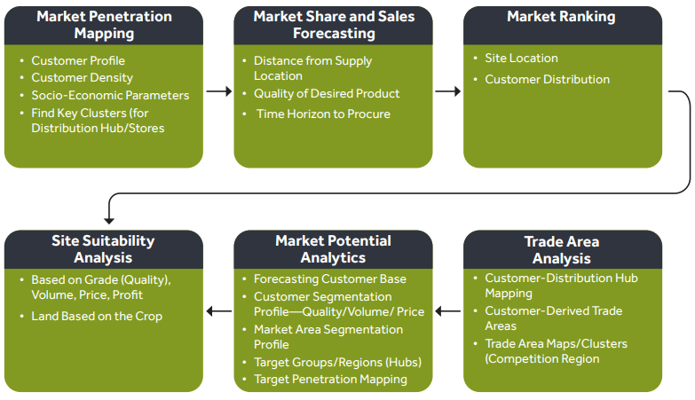
By analyzing data on crop yields, weather patterns, and market trends, crop market analytics helps farmers optimize their crop production, traders and investors make informed decisions about buying and selling crops, and policymakers make informed decisions about agricultural policies. Region-wise crop production, distribution network, demand location, and market trends help identify areas where additional investments could be required to improvise crop production for upcoming years.

End-to-End Mapping of the Supply Chain 

1. Supply/ Produce Analytics

  • Production Quantity
  • Produce Quality/Grade
  • Cost to Produce
  • Time-to-Market
  • Time to Process

2. Demand Analytics

  • Market Penetration Mapping
  • Market Share and Sales Forecasting
  • Market Ranking
  • Site Suitability Analysis
  • Market Potential Analytics

3. Supply Chain Constraints

  • Distance and Other Road Constraints
  • Multi-Mode Transport
  • Readiness for Storing, Processing, and Exporting Crops without
  • Loss/Damage Compliance Parameters

4. Multi-Objective and Multi-Criteria Analysis

  • Time to Deliver
  • Volume/Quantity
  • Revenue Price Profit
  • Desired Quality
  • Reduced Emission/Waste/Pilferage

Key Demand Analytics Features

1. Farming clusters or regions for seeds, fertilizers, and pesticides with quality and quantity. 

2. Demand clusters for produce supply.

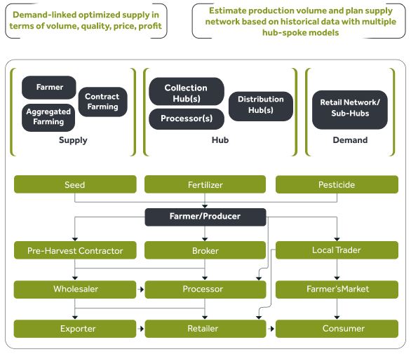
A typical agriculture supply chain (below) shows the farmer-supplier through distribution or processing or collection hubs, often with many intermediaries. The produce is generated through multiple arrangements—contract farming, aggravated farming, and others.

Screenshot_87

EO analytics help provide the region-wise or farm cluster-wise production quantity and time-to-market based on crop phenology. This information helps to schedule the delivery of produce to 
demand points.

i. Crop Demand Analytics

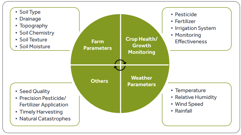
Crop production volume depends on various parameters and is based on integrated analysis of these parameters such as selection of land (including soil, hydrology, and more), irrigation supply, and weather patterns, which helps farmers make informed decisions about when to plant, irrigate, and harvest their crops. This can help them maximize their yields and duce is then sold to minimize their weather-related losses due to droughts or floods.

Parameters that help with estimation of good and healthy production:

Screenshot_88

ii. Supply Analytics

The farmer-producer-broker-processing plant-delivery supply chain is a crucial aspect of the agricultural industry. It involves a series of interconnected steps that ensure the timely and efficient delivery of fresh produce from the farm to the end consumer. The process begins with the farmers who grow the crops and harvest them. The produce is then sold to brokers who act as intermediaries between the farmers and the processing plants. The brokers ensure that the produce is of high quality and meets the required standards. The processing plants then take over and transform the raw produce into finished products ready for consumption. Finally, the products are delivered to retailers and consumers through a network of distributors and logistics providers. This supply chain is essential for ensuring that fresh and healthy produce is available to consumers all year round.

Artboard 1 2

iii. Solution Architecture

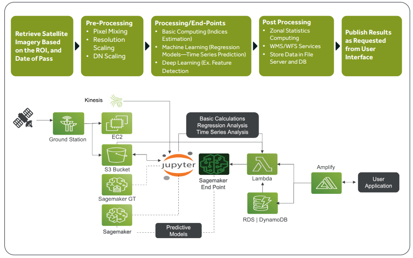
GeoAI is the application of MLOps in the geospatial industry. This involves the analysis and interpretation of geographic information from satellites, drone imagery, and data from other diverse, disparate sources—ground truth describing soil, land use, rock, crop and other data, and weather data. GeoAI automates the geospatial ML model life cycle and provides the necessary tools for model orchestration and continuous delivery and integration of geospatial ML models into production environments. GeoAI adoption shortens development and operational processes in the geospatial industry, leading to faster and more efficient analysis of geospatial data. Kubernetes and an automated model orchestrator are important components of GeoAI, allowing for scalability, efficiency, and high availability of geospatial ML pipelines.

iv. Geospatial Machine Learning Pipeline

A geospatial machine learning pipeline refers to the process of managing the end-to-end life cycle of a geospatial machine learning project. This involves data collection, pre-processing, model training, evaluation, deployment, and monitoring. 
Here's a high-level overview of the steps involved in a typical geospatial machine learning pipeline: 

  1. Data collection: Gather geospatial data from various sources such as satellite imagery, GPS data, or GIS databases. 
    This data may include raster, vector, or point cloud formats and various data from secondary sources. 
  2. Ingestion
  3. Data pre-processing: Clean, pre-process, and transform the raw geospatial data into a format suitable for machine learning algorithms. This may involve data normalization, feature extraction, and data augmentation.
  4. Data analytics
  5. Output—dashboards, reports, published map, and APIs for downstream analytics.

Screenshot_90

Representative ML Pipeline Architecture over AWS

Screenshot_91

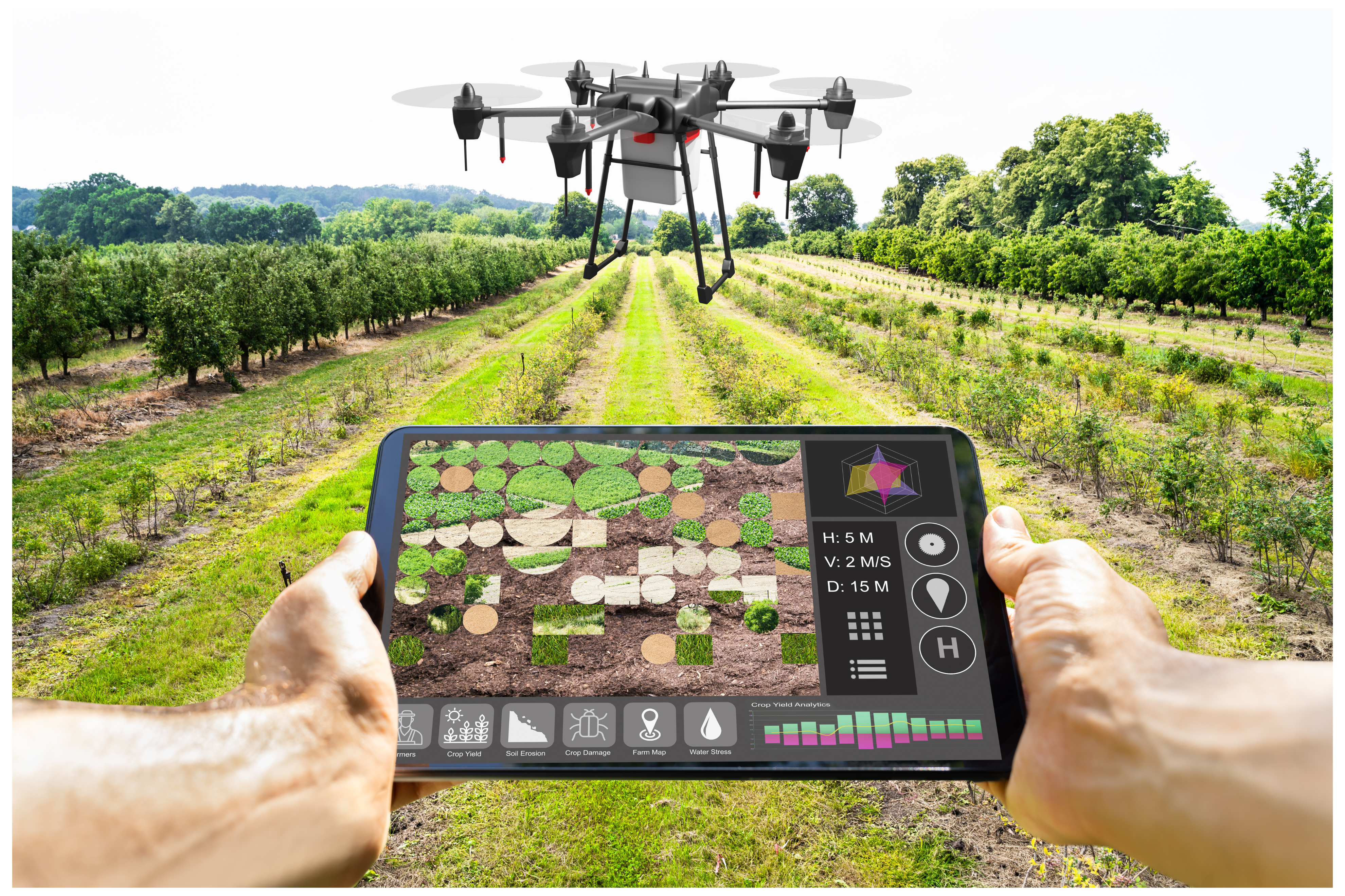
Benefits of GeoAI in Agriculture

  • Enhanced decision-making: Empowers farmers with accurate and timely information, enabling them to make data-driven decisions to optimize operations, improve productivity, and mitigate risks effectively.
  • Improved crop health and yield: Estimating early detection of crop diseases, pests, and other stress factors and addressing issues in advance optimizes crop quality and yield.
  • Sustainable farming practices: Enabling precision agriculture techniques and optimizing resource usage.
  • Effective environmental management: Identifying the right farming land with less erosion risk, efficient water resources, soil quality that demands less or zero usage of pesticides and fertilizers to reduce environmental impact.
Images 2

Original equipment manufacturers (OEMs) are under relentless pressure to accelerate product design and development, extend equipment life cycles, improve product performance, and develop localized products for different market needs all while keeping their production costs competitive. Cyient’s end-to-end heavy equipment and industrial product design engineering services helps your organization remain competitive, deliver new product innovation, and maintain asset health using IoT and predictive analytics.

Cyient supports OEMs in developing cutting-edge industrial equipment, including industrial tools, controllers, process and power distribution equipment leveraging our extensive knowledge in heavy equipment design and industrial product design engineering services. Designed for both equipment manufacturers and operators, our ready-to-deploy solution frameworks, for heavy equipment, material handling equipment, industrial products and industrial machinery, span the entire product life cycle-development, optimization, localization, value analysis and value engineering, design-to-build, and aftermarket services.

We can support all aspects of design and manufacturing, offering system engineering for the design, build, and maintenance aspects of the product life cycle. Our capabilities include:

  • Product development engineering
  • Preventive and predictive analytics
  • IoT solutions
  • Embedded software & electronics
  • Manufacturing engineering
  • Electronic manufacturing
  • Geospatial, GIS and data management solutions
  • Asset health monitoring

Conclusion

In conclusion, Geospatial AI, blockchain and earth observation have the potential to revolutionize supply chain management in agriculture. Together, these represent a powerful combination of technologies to address end-to-end sustainable agriculture supply chain management and support the development of effective strategies for managing natural resources and protecting the environment. Cyient has been building offerings using Earth Observation data with AI/ML in Crop Science and allied Geoscience solutions for Energy, Utilities and Mining industries.

About the Author


Nihar-1

Nihar R Sahoo is a PhD in Geosciences and Mineral Exploration with specializations in GIS, Remote Sensing and Applied Statistics, and has over 23 years of industry experience. His interest areas include building end-to-end development and deployment and operationalization of geospatial solutions with earth observation and allied data.

About Cyient

Cyient (Estd: 1991, NSE: CYIENT) is a global Engineering and Technology solutions company. We collaborate with our customers to design digital enterprises, build intelligent products and platforms and solve sustainability challenges. We are committed to designing tomorrow together with our stakeholders and being a culturally inclusive, socially responsible, and environmentally sustainable organization.

For more information, please visit www.cyient.com