Abstract

Ensuring the safety and health of pipelines is of utmost importance for pipeline operators as it involves not only the risk of theft but also the potential loss of life and significant downtime. According to a report by the US Department of Transportation, in 2020, there were 321 pipeline incidents resulting in 10 fatalities and 64 injuries, with an estimated property damage of $58.8 million.

Currently, pipeline operators rely heavily on manpower to monitor their networks, which incurs substantial costs. However, the accuracy of monitoring diminishes over time, and accessing the right of use (ROU)/right of way (ROW) can be a challenge, leading to blind zones or skip zones in the pipeline vicinity. These issues can lead to loss of lives, significant financial losses, and penalties.

This whitepaper tackles ways to solves these challenges through developments in the emerging field of GeoAI. GeoAI monitoring utilizes earth observation technology, which enables remote monitoring of pipelines with minimal human interaction. This approach ensures unbiased and cyclic data collection, leading to improved accuracy and reduced costs and risk to life. According to a report, the global artificial intelligence market was valued at USD 65.32 Billion in 2020 and is projected to reach USD 175.63 billion by 2028, growing at a CAGR of 41.23% from 2021 to 2028. This growth is primarily attributed to the increasing demand for location-based services and real-time data analysis in various industries, including oil and gas.

Introduction

The oil and gas pipeline industry is a highly regulated sector due to the high risks involved in the transportation of crude oil and high-pressure gas over long distances. Globally, the network of oil and gas pipelines spans over 2,069,000 kilometers. India has about 29,000 kilometers of transmission network, of which approximately 20,000 kilometers is dedicated to high-pressure gas transmission. The construction of high-pressure pipelines involves crossing barren lands, agricultural areas, forests, urban land, and rivers. Major sections and stations of these pipelines are constructed in open areas to reduce the impact of any untoward incidents or disasters. Real-time monitoring of these pipelines is essential to ensure efficient and effective operations.

The pipeline transmission network faces several challenges which include land use changes due to urbanization, aging infrastructure, oil or gas spills, and asset health. Pipeline regulatory compliance is another significant challenge, considering the extent of violations in health, safety, and environmental aspects that lead to huge penalties for most oil and gas companies. 

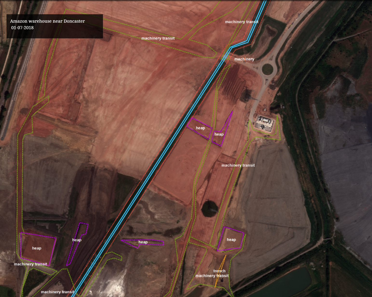
To address these challenges, a cost-effective solution that leverages earth observation (EO) technology has proven especially useful. This solution utilizes spatial, temporal, and spectral resolution data to detect anomalies such as leaks, encroachments, and other spatial-temporal changes along the pipeline. The solution is augmented with the Industrial Internet of Things (IIoT) to provide detailed  monitoring of assets in critical and sensitive areas. It also employs artificial intelligence/machine learning (AI/ML) algorithms to analyze earth observation data from multiple sources covering optical, hyperspectral, and synthetic aperture radar (SAR) of varied resolutions.

The solution provides automated regulatory compliance functionality as per the obligations set by pipeline safety regulations from authorities such as the Petroleum and Natural Gas Regulatory Board (PNGRB), Pipeline and Hazardous Materials Safety Administration (PHMSA), and others. The solution also lends itself to Environmental, Social, and Governance (ESG) reporting.

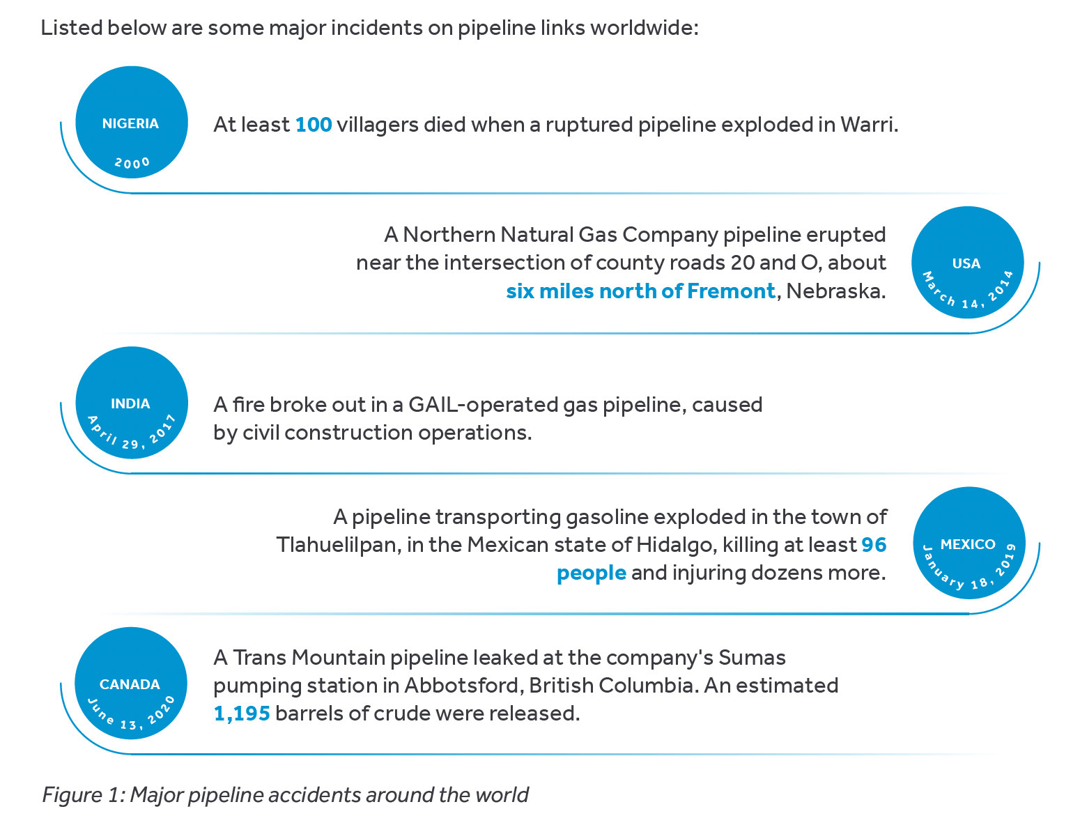
Regulators worldwide are implementing new safety regulations for pipelines, with PHMSA's Mega Rule recently pressuring operators to use technology in daily operations for safer execution. Due to operational negligence, there have been incidents of theft, particularly of crude oil pipelines, resulting in financial losses and weak links in the system. Pipeline explosions due to operational negligence have resulted in massive loss of life.


2-Jun-02-2023-11-12-13-2445-AM


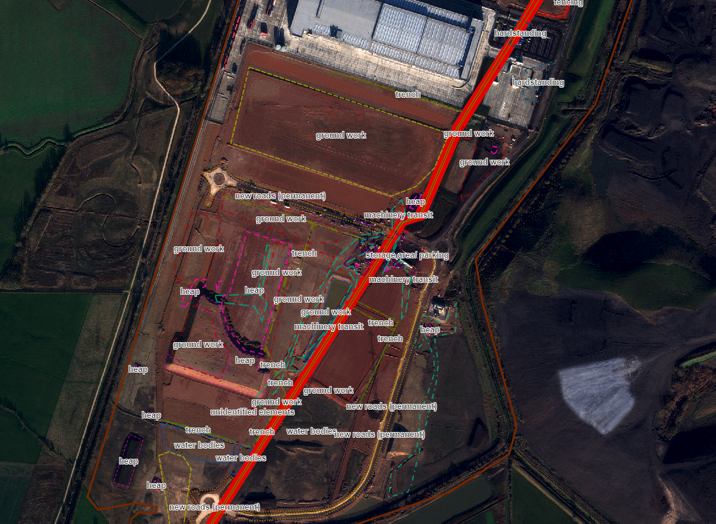
The highly dynamic nature of the industry and the need for accurate document management have underlined the need for digitization. The encroachment of man-made and natural objects along the ROW of pipelines triggers third-party damage, while aging infrastructure and the disconnect between the field and office create additional challenges.

The Larger Problem

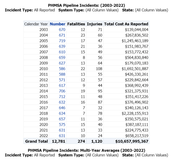
Massive penalties are imposed on operator companies due to accidents. Understanding the impact of these accidents is imperative to improving the operational management of these pipelines. 

  • The pipeline, which spans hundreds of kilometers and is accompanied by a right-of-way or right-of-use buffer of 15 to 25 meters, creates difficulties in monitoring. In addition, the rugged terrain, challenging environment, high operating pressure, and human intervention create difficult working conditions. Even minor errors can pose a significant threat.
  • Humans are responsible for conducting line walks to ensure that every inch of the pipeline is safe. However, inaccessible locations or lethargy can become serious issues.
  • The lack of system visualization increases the likelihood of hazards.
Modern technology allows oil and gas operators to leverage the wide suite of off-the-shelf or open-source technologies to create viable solutions. AI and ML have proven especially useful for similar use cases in other industries. More importantly, the exponential increase in satellite data also delivers the potential to be harnessed in proactively managing and mitigating disasters.

1-Jun-02-2023-11-14-10-1890-AM

2-Jun-01-2023-10-51-45-5802-AM

1-4

Regulatory-strategy

Regulatory strategy for new product development

Regulatory-compliance

Regulatory compliance for sustenance

EU MDD to EU MDR2017745 transition

EU MDD to EU MDR2017/745 transition

Satellite-Based Geoai Monitoring Tool

Over the past 20 years, the United States alone has suffered losses of $10.66 billion in mis-managed pipeline leaks or damages. There have been multiple incidents worldwide where pipeline leaks have resulted in deaths. Cyient is currently developing a satellite-based Geo-AI tool that will prove useful to pipeline operators, particularly in areas where human access is limited. Incidents such as spills, theft, and leaks leave traces on the surface that can be identified through satellite imagery.

This tool also helps reduce an organization’s carbon footprint as it notifies users of any anomalies within the system. It identifies any natural or man-made encroachments, reducing third-party damage to pipelines. It is essential to closely monitor pipelines in disaster-prone areas vulnerable to floods, storms, earthquakes, forest fires, and landslides, as monitoring becomes challenging when disaster strikes.

Cyient’s two-part solution for acquiring satellite data 

The first part involves using open-source, coarse-accuracy satellite data that is freely available and has a good data acquisition frequency. The AI tool can raise a flag when anomalies are identified using this data.

The second part involves acquiring satellite images of the anomaly area to understand the root cause. This method is known as the "tip and cue" method of image acquisition. Together, these practices reduce the extra cost of image acquisition and processing.

  • High-resolution satellites are equipped with tasking algorithms to help understand minute details along the pipeline route. The tool also creates notifications if there are any illegal activities along the pipeline.
  • Multiple open-source satellite images cover the entire globe in less than five days, and a mix of multiple images can reduce the repetition window to three to four days. This means that each place on earth can be covered in three to four days.
Feasibility-assessment

Feasibility assessment


Understanding the product and identifying applicable standards as per the intended purpose of the product.

Product-development

Product development


Identifying applicable regulatory requirements and preparation of regulatory assessment report.

Product-launch

Product launch


Compiling the technical documentation, product registration, and launch.

There are several benefits to using a GeoAI approach:

Reduced incidents

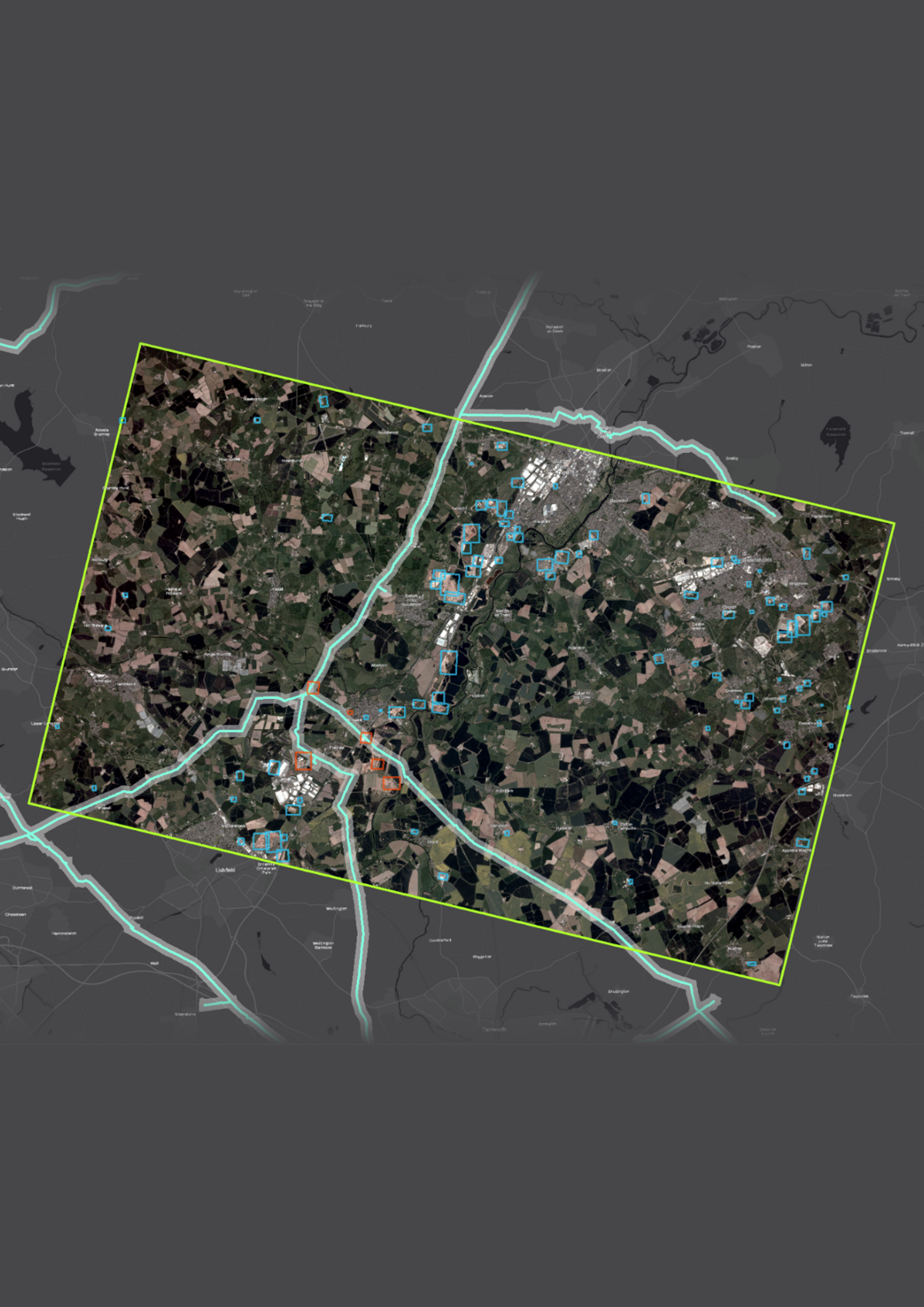
GeoAI allows the monitoring of the pipelines using earth observation and identifying anomalies in the pipeline system. This helps organizations take preemptive actions or act quickly after an incident.

Unique features 

The proposed system empowers the pipeline operator with a stack of the latest technology such as satellite data, AI, ML and visualization to reduce risks in operations and management. It can flag incidents by pinpointing their location and can also help in determining the criticality of the incident and the appropriate course of action.

Cost-saving

Using open-source technology, macro-level identification of issues can be achieved, and high-resolution satellite data can be used for micro planning. Multiple companies now offer satellite data tasking facilities, making this approach less expensive than dealing with accidents that occur.

Error-free monitoring

The vast amount of satellite data makes manual review impractical and prone to human error. AI/ML uses patterns in the data to identify variation, as it can pick up anomalies in an unbiased manner. The addition of a human in the loop can confirm any issues along the pipelines.

Faster, accurate response

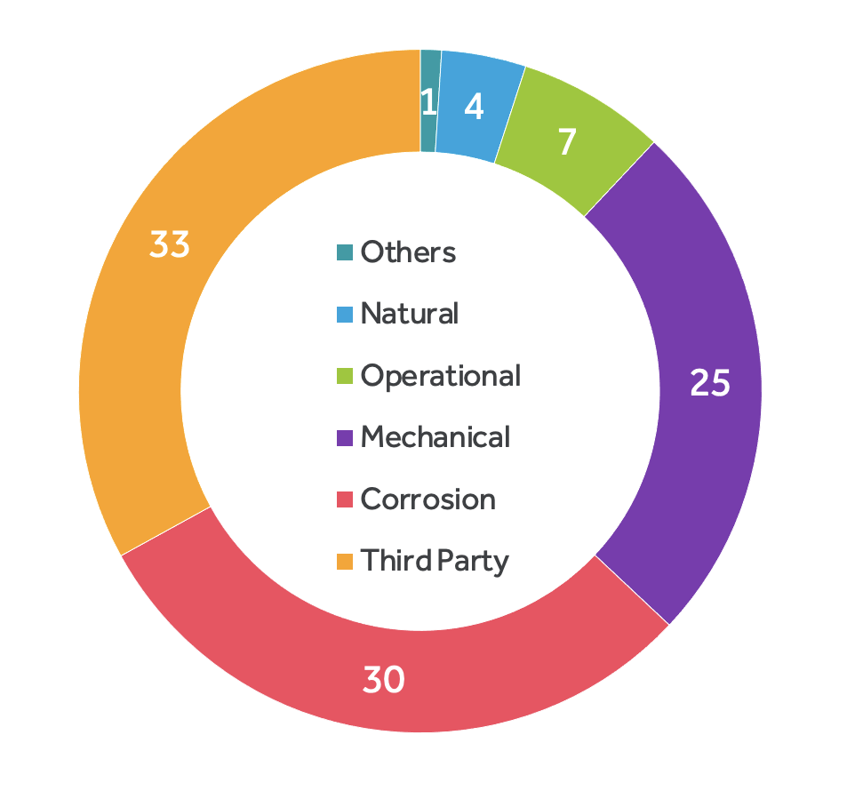
Currently oil thefts in some countries are identified around 10 days post the incident. This results in enormous human efforts and cost to identify the root cause, The proposed solution can reduce the reaction time and reduce the chances of a bigger incident. Due to lack of information about the construction along the pipeline it becomes almost impossible to identify the hotspot for third-party damage. GeoAI provides information about construction activity along the pipeline reducing the probability of damage. Currently around 33.3% of pipeline damage is due to third parties. This suggests that reducing construction along the pipeline can help reduce the threat to operations.

Screenshot 2023-05-22 at 4.49.27 PM

Figure 3: Third-party pipeline damage is the highest, at around 33.3%. This suggests that reducing construction along the pipeline can reduce the threat the operations

Case in point

shutterstock_417316783

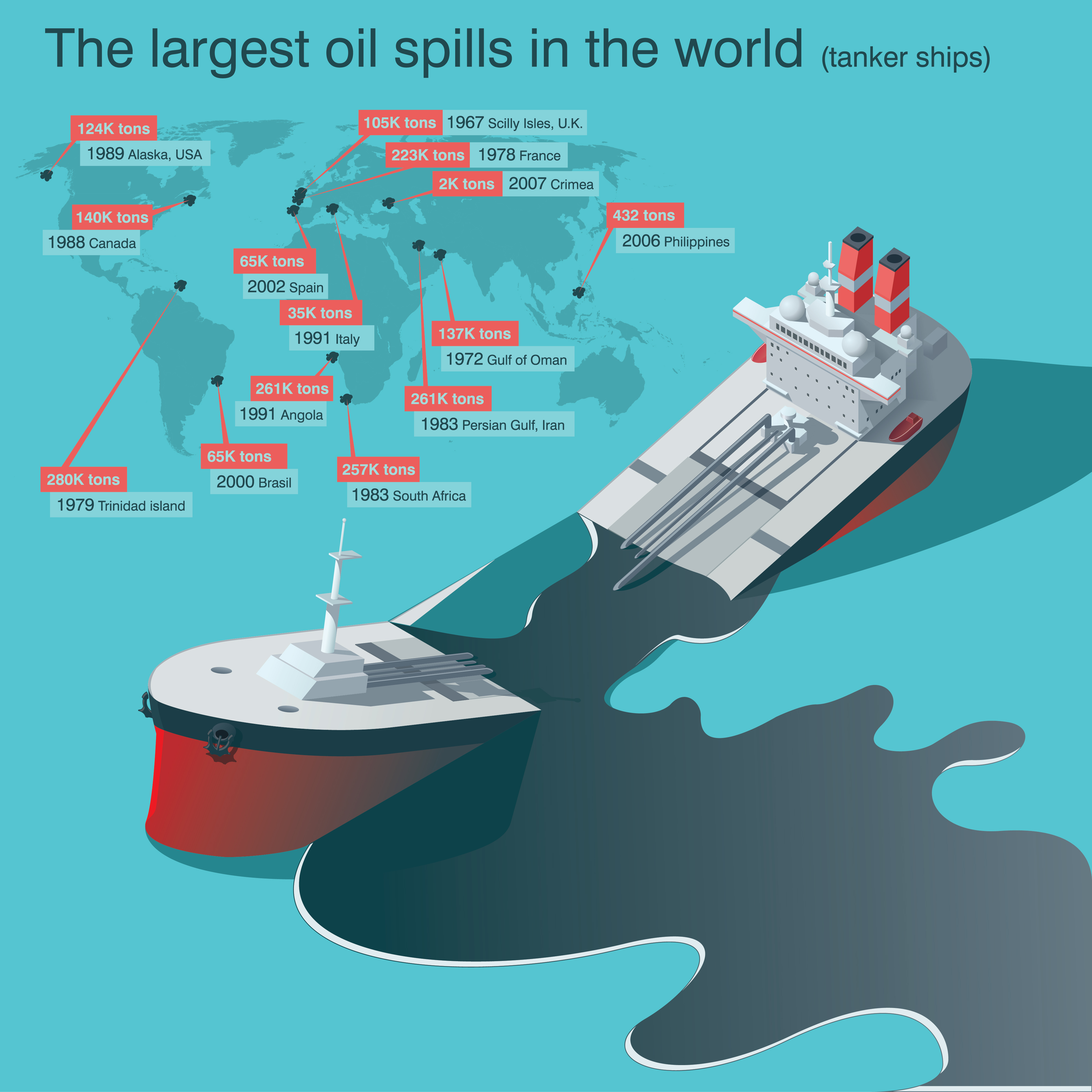
Recently, an oil spill occurred in the Keystone Pipeline which carries crude oil from Canada to the US. The incident occurred near a small county in Kansas, resulting in a massive workforce being deployed 24/7 to manage the oil spill. Approximately 14,000 barrels of crude oil had spilled into a creek, and the impact of this spill had spread over 2600 miles of land in the pipeline's vicinity, requiring extensive cleanup efforts. The cleaning process has been going on for more than two months and is yet to be completed. This area has seen multiple incidents of oil spills, and the Keystone Pipeline spill resulted in financial losses of around $3 billion and six fatalities. The incident also had an economic impact, pushing up crude oil prices rise by 5% for a while.

Change In The Pipeline

Oil and gas transmission via pipelines is a tightly regulated and closely monitored global operation. Due to the extensive geographical coverage, significant risks are involved. 

Pipeline operators have slim profit margins and multiple challenges to manage.

The safety of the pipeline network is thus a top priority for any operator, not just due to fines and penalties but also because of potential operational blockages. Any interruption in product transmission or incidents in the field can lead to financial and reputational loss. The use of Geo-AI can help reduce the chances of such incidents occurring by:

  • Providing timely notifications of details, anomalies, and activities along the pipeline 
  • Delivering detailed imagery using EO data to cover various points across the earth within a short period of time 
  • Using AI and ML to help ascertain variations quickly and take appropriate action
cloud-based solution


A cloud-based solution to accelerate the regulatory compliance process. It helps to search worldwide regulations, and offers a digitized form regulation database for easy search and analysis. The standard module consists of a library of 1500+ international standards such as ISO/IEC/AAMI.

impact-analysis


The solution offers a device classification tool, device-specific compliance, and regulatory intelligence services such as regulation assessment, gap assessment, and impact analysis.

02-08


Its regulatory watch feature monitors changes in regulations and provides a personalized news feed to users consisting of regulations news, safety communication, and warning letters.

Contents of a Clinical Evaluation Report

  • Executive Summary
  • Scope
  • State-of-the -Art Evaluation
  • Subject Device Description
  • Equivalence Study
  • Data Sources—Identification and Appraisal
  • Post-Market Experience and Surveillance
  • Risk Benefit Analysis
  • Conclusion

Challenges in Clinical Evaluation

  • Updated risk management data, where full risk management data are defined as delivery of the following: Risk analysis report + Failure Mode and Effects Analysis (FMEA) + Process Failure Mode and Effects Analysis (PFMEA) + Risk management report.
  • Biocompatibility reports.
  • Verification and validation (V&V) testing reports.
  • Full PMS data as an indication of an active PMS program, where full PMS data are defined as delivery of all the following: Sales + Complaints + Trend reporting + Corrective and Preventative Actions (CAPAs) if issued + Field Safety Corrective Actions (FSCAs) if applicable + PMCF data + data from registries.
  •  Technical documentation as per Annexes II and III to the MDR.
  • Copies of the instructions for use (IFU) and other applicable labeling documents.
  • Essential Requirement (ER)/General Safety and Performance Requirement (GSPR) checklists.
  •  Compliance with applicable standards.
  • Previously released CER, regardless of its compliance statement.


shutterstock_2014047518

How a GeoAI solution could have helped

The GeoAI solution could have alerted appropriate authorities about the oil spill early, allowing them to act before it spread further. Also, the heavy environmental impact of transferring of tar sands could have been mitigated. Around 250 people were engaged for two months to clean the land and the water polluted due to the oil spill. This solution could’ve detected this anomaly early and flagged it to the concerned authority to reduce the impact.

About the Author


Diptesh V. Kadam is a gold medalist in geology from The Maharaja Sayajirao University of Baroda. He has 16+ years of industry experience, which includes 10 years in the O&G industry. His expertise spans surveying, planning, designing, and overseeing operations and maintenance of pipelines. His areas of interest are building end-to-end geospatial solutions for oil and gas pipelines for better and safe operations.

About Cyient

Cyient (Estd: 1991, NSE: CYIENT) is a consulting-led, industry-centric, global Technology Solutions company. We enable our customers to apply technology imaginatively across their value chain to solve problems that matter. We are committed to designing tomorrow together with our stakeholders and being a culturally inclusive, socially responsible, and environmentally sustainable organization.

For more information, please visit www.cyient.com