GeoAI in Crop Analytics and Sustainable Agriculture
Written by Nihar Ranjan Sahoo 30 Jan, 2023
Agriculture is the backbone of the global economy, and with a growing population, the world will need to produce 50% more food by 2050. AI is significantly impacting the world's most vital sector— agriculture—by expanding its footprint on the ground. Following its forays into the healthcare, automotive, manufacturing, and finance industries, artificial intelligence is now providing cutting-edge technology in agriculture for harvesting with improved productivity and crop yield.
With the advent of massive open-source earth observation (EO) data, easy accessibility over cloud platforms, and new ways of solving problems across the value chain for most industries, geospatial artificial intelligence (GeoAI) has been the frontiers of spatial analytics. The integration of artificial intelligence and geospatial information technology (GIT) with agriculture is further shaping the future of agriculture, making it more productive, profitable, and sustainable.
Role of MLOps in precision agriculture
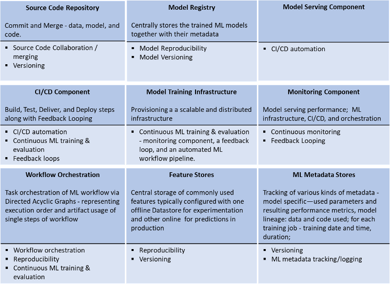
Geospatial machine learning operations (MLOps) is a set of practices that aims to deploy and maintain machine learning models for earth observation imagery in production reliably and efficiently. It helps build a robust and scalable DevOps culture to provision end-to-end conceptualization, implementation, monitoring, and deployment of machine learning solutions.
MLOps facilitates the creation of machine learning products by leveraging CI/CD automation, workflow orchestration, reproducibility; versioning of data, model, and code; collaboration; continuous ML training and evaluation; ML metadata tracking and logging; continuous monitoring; and feedback looping. MLOps aims to:
- Have easy, repeatable, portable deployments on diverse infrastructure.
- Deploy and manage loosely-coupled microservices.
- Scale based on demand.
Key challenges in agriculture
With humongous spatial data from earth observation and advances in analytical capabilities, the agriculture industry faces numerous challenges in optimizing and automating the end-to-end DevOps pipeline for GeoAI solutions, including:
- Retrieval and pre-processing of satellite imagery.
- Poor communication and synchronization among research, engineering, and operations teams on the models being built, retrained, versioned, deployed, and operationalized.
- Poor reproducibility assurance.
- Challenge in implementing changes in objectives quickly.
- Enabling CI/CD support for data and assets.
Geospatial data keeps getting timely updates since processing data from a satellite, drone, or 360-degree mobile imageries has varied challenges. Tasks such as collecting, cleaning, transforming, enhancing, segmenting data, and training and deploying models are time-consuming and often involve iterative executions.
Based on Gartner’s study, less than half the AI projects make it to production globally, while the rest do not go beyond Proof of Concept. This is primarily due to the absence of the right training data, data quality, chosen model or algorithm, or data localization. To optimally leverage geospatial data to improve the agricultural industry’s landscape, MLOps is efficiently enabling an end-to-end automation platform for iterative executions in ground truthing data validations, training, and deploying models and delivering results with 60% reduced cost and effort.
What does our solution offer?
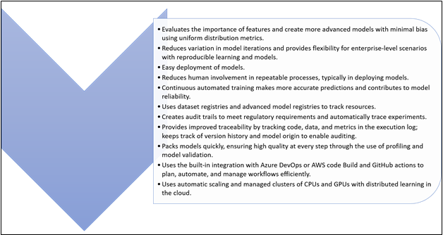
Despite ML-driven analysis generating a noise-free, accurate, and consistent output, its dependency on ground truth validation has been a major hindrance. Ground truth is crucial to train and validate the model, for it classifies and evaluates every agricultural zone and helps identify crop varieties. MLOps establishes DevOps for an ML platform to effectively collaborate with data, business analysts, engineers, data scientists, and researchers to accelerate model development and its deployment through monitoring and validating management systems. Here is our solution framework to help you better understand how you can improve your crop assessment method by leveraging our offering:

MLOps streamlines model training and model deployment pipelines, using CI/CD to simplify retraining, integrating machine learning easily into existing release processes, and using advanced data analysis to improve model performance over time.

Conclusion
Machine learning on open-source Sentinel 2 data has worked effectively and efficiently in classifying crop variety and health. Certain preprocessing, such as cloudy pixels and atmospheric corrections, can be added to the pipeline—crop yield, production quantity forecasting, identifying crop stress areas, supply chain for seed, fertilizer, pesticide and produce, estimating soil organic carbon—while building a comprehensive system on precision agriculture. The solution covers building an expert system that uses soil, water (drainage pattern), weather conditions, and other factors to strategize for enhanced production.
Why Cyient?
As a technology enabler and solutions provider, Cyient works closely with industry experts to understand the concerns and challenges. With the vision of Designing Tomorrow Together, we enable our customers to apply technology imaginatively across their value chain to solve problems that matter. We aim to provide sustainable solutions and facilitate the adoption of disruptive technologies to conserve valuable resources. Cyient is invested in building a generic comprehensive end-to-end processing platform for real-time analytics of earth observation data on precision agriculture for enhanced productivity.
About the Author
Nihar R Sahoo is a Ph.D. in Earth Sciences specializing in GIS, Remote Sensing, and Applied Statistics. He has over 23 years of industry experience. His areas of interest are building end-to-end development, deployment, and operationalization of geospatial machine learning solutions with earth observation data.
.png?width=774&height=812&name=Master%20final%201%20(1).png)