-
.jpg?width=1680&height=800&name=Frame%20905%20(13).jpg)
 ESRI
ESRI
PARTNERSHIP
Transforming Network Management with Esri Enterprise GIS
Organizations in the utility and infrastructure sectors face challenges from fragmented network data, legacy systems, and the need for real-time insights to optimize maintenance and operations. To address this, Cyient partners with Esri, a leader in Geographic Information System technology, to deliver advanced utility solutions. As an Esri Gold Partner, Cyient’s focus on spatial data management reflects the founder’s alignment with the Esri GIS platform. This collaboration enables the deployment of Esri’s ArcGIS platform, enhanced by Cyient’s expertise, to resolve data inconsistencies, fill network model gaps, and optimize workflows.
Cyient has earned recognition for its investment in Utility Network Management Specialty , and Imagery Specialty .
As an early adopter of Esri software, it stays ahead of evolving GIS technology. By leveraging scalable methodologies and proprietary tools, Cyient facilitates seamless migration to Esri’s Utility Network model, helping utilities modernize EAM systems and improve data integrity. In addition, Cyient is helping users make smart decisions using ArcGIS, enabling more informed, data-driven choices across utility operations.


Addressing Challenges in
Esri Utility Network Model Implementation
Organizations transitioning to the Esri Utility Network model often encounter several critical challenges:
Data integrity issues
Inconsistent and incomplete GIS network data can hinder smooth and accurate migration to the new model.
Network completeness gaps
Insufficient data coverage in the source network can lead to gaps in the target Utility Network model, compromising overall system accuracy.
Customization conflicts
Overly customized workflows in legacy systems can result in incompatibilities during migration, requiring careful adaptation.
Change management resistance
Long-standing users of legacy systems may face difficulties adapting to the new Utility Network model, necessitating robust change management strategies.
Understanding
the Stages of UN
Migration
Migrating to the Esri Utility Network involves a series of structured stages, each designed to ensure a seamless transition from legacy systems to the advanced capabilities of the Utility Network model.
.jpg?width=458&height=560&name=3X1%20CARD%20(8).jpg)
A comprehensive plan outlining the phased migration strategy, timelines, and dependencies to guide the entire transition effort.
.jpg?width=458&height=560&name=3X1%20CARD%20(9).jpg)
A limited-scope implementation that validates the roadmap, identifies risks, and fine-tunes approaches before full-scale deployment.
.jpg?width=458&height=560&name=3X1%20CARD%20(10).jpg)
Deployment of Esri GIS components with a focus on aligning and optimizing key business processes to leverage the capabilities of the Utility Network.
.jpg?width=458&height=560&name=3X1%20CARD%20(11).jpg)
Designing a scalable and secure technical architecture, including cloud-based deployment strategies, to support the long-term vision of the Utility Network.
.jpg?width=458&height=560&name=3X1%20CARD%20(12).jpg)
Ensuring ongoing technical and functional support for GIS platforms and integrated applications during and after migration.
.jpg?width=458&height=560&name=3X1%20CARD%20(13).jpg)
Enhancing the Utility Network implementation with extensions that support leak detection, regulatory compliance, and field workforce mobility.
Our Approach to ESRI
UN Migration

Cyient Offers the Lowest Risk and Most
Cost-Effective Esri Solutions
.png)
What Cyient brings:
- Deep expertise in deploying Esri technologies and strong collaboration with Esri.
- Certified team of resources experienced in award-winning Esri projects for utilities.
- Comprehensive understanding of how Esri platform integrations, such as ERP, CRM, Mobile, and IoT systems, work
.png)
What you gain:
- Tailored and stable solutions that ensure consistent and reliable performance.
- Access to global best practices and methodologies for cost-effective and risk-free Esri implementations.
- Seamless integration of GIS data into broader IT environments, unlocking more value from data.
Building with Esri’s
Advanced GIS Technologies

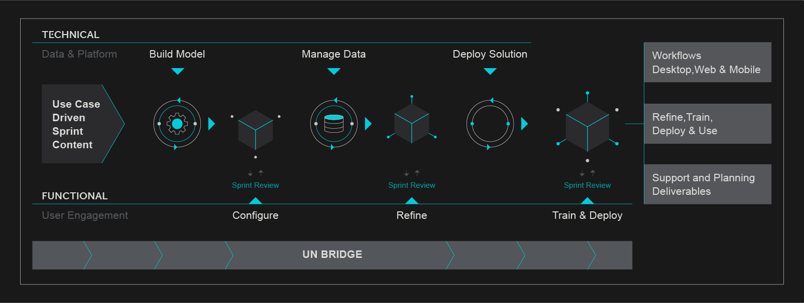
UN Workflow
Expertise
- UN Asset Modeling
- Business Process Discovery
- Workflow Configuration
- Migration
- Conversion
- Network Alignment
- Integration

Operational & Regulatory Planning
- Operational Dashboards
- 811 Integrated Tracking
- Outage Dashboards
- Regulatory Reporting
- Crew Monitoring
- Mobile Workflow Configuration

Engineering
Solutions
- Design Integration
- Workorder Dashboard
- Field Workflow/Redline Configuration
Intelligent Engineering
with Cyient

Transform
Revolutionize network management by implementing Esri’s Utility Network, ensuring smooth migration and operational efficiency.

Integrate
Enable seamless Esri platform integration with ERP, CRM, Mobile, and IoT systems, ensuring interoperability across the customer’s IT ecosystem.

Innovate
Utilize a strong understanding of Esri tools and methodologies to deliver forward-looking solutions that address complex industry challenges.

Efficiency
Tailored, reliable solutions engineered for consistent performance, combined with global best practices and methodologies to deliver cost-effective, low-risk Esri implementations.

Value
Enhanced IT ecosystems through flawless integration of GIS data, unlocking actionable insights and maximizing data potential.
In the Spotlight
.png)
Esri Recognizes Cyient’s Innovation
Cyient received the 2023 IMGIS award from Esri for their innovative use of ArcGIS software. Richard Cooke, Corporate Director and SVP of Global Business Development at Esri, stated, “We are proud to partner with Cyient to foster the use of GIS technology to support our mutual customers in improving infrastructure.”

Standardized Utility Network for a US-Based Energy and Water Provider
Cyient implemented an Esri Utility Network GIS system in a secure Azure cloud for 14 operating companies across water, gas, and electricity. Key outcomes included a 15% increase in asset reliability, 20% reduction in unplanned downtime, and improved customer satisfaction by 15%.

Enterprise GIS Implementation for a Leading UK Water Utility
Cyient supported a major transformation program by implementing Esri’s ArcGIS Utility Network and 30+ custom integrations. Results included improved asset lifecycle management, compliance, and operational flexibility.

Enhanced Outage Management for a New Zealand Utility
Cyient deployed Esri’s CIM Network Model in Azure cloud infrastructure, ensuring accurate data migration and improved system functionality. Benefits included enhanced geospatial data consistency, better integration, and increased performance across customer service, network control, and field operations.
Insights

Cyient Receives Esri’s “Release Ready Specialty” Partner Status
Learn how Cyient's strategic partnership with Esri empowers organizations to tackle geospatial challenges, leverage advanced ArcGIS technology, and drive innovation in geospatial solutions for industries worldwide.

Cyient Attains Gold Status in the Esri Partner Network
Discover how Cyient’s Gold Partner status in the Esri Partner Network enhances geospatial solutions, tackling challenges in telecommunications, utilities, mining, and defense.

Cyient Receives Modern Network Management Award at Esri Infrastructure Management and GIS Conference
Discover how Cyient’s Modern Network Management Award at the 2023 Esri IMGIS Conference showcases its innovative use of Esri’s ArcGIS platform to enhance data accuracy, drive digital transformation, and support sustainable infrastructure goals.
.png?width=774&height=812&name=Master%20final%201%20(1).png)